日本全国の錦絵・写真等を紹介する新しい電子展示会「錦絵と写真でめぐる日本の名所」を公開しました。
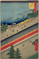
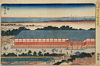
Sanjusangendo
Back : Find on a modern map Back : Find on a detailed map of Edo Back : Koto-ku Back : Fukagawa ezu
- Current Address
- Koto-ku, Tomioka
- Description
- Constructed in 1642 in Asakusa Matsubacho as a place of training for Japanese archery modelled on Kyoto's Sanjusangen-do Hall. Destroyed in a fire in 1698, it was reconstructed on the eastern side of the Tomioka Hachiman-gu Shrine in 1701. It is called Sanjusangen-do Hall because there are 33 ken (a unit of measurement) between the pillars in the front. Because the intervals between the pillars was 2 ken, the actual size of the hall was 66 ken (approximately 120 meters) north to south and 4 ken (approximately 7 meters) east to west. "Toshiya" archery was carried out shooting arrows from the south to north of the hall, and the hall prospered as one of Edo's meisho (famous places). The hall was demolished in 1872 as a result of the Haibutsu Kishaku (anti-Buddhist movement at the beginning of the Meiji Era).


