日本全国の錦絵・写真等を紹介する新しい電子展示会「錦絵と写真でめぐる日本の名所」を公開しました。
Sendagi
Back : Find on a modern map Back : Find on a detailed map of Edo Back : Bunkyo-ku Back : Komagome ezu
- Current Address
- Bunkyo-ku, Sendagi
- Description
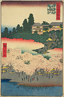
- This area was originally forest land called Sendagi Ohayashi, and was contributed as a supply area for firewood after the construction of Ueno Kan'ei-ji Temple. It is said that the area was named Sendagi because senda was the amount of goods carried by a thousand horses and a senda of firewood was cut each day. Because the top of Dango-zaka Hill, which runs from Sendagi to Yanaka and Ueno, overlooks Tsukuda-oki , it was also known as Shiomi-zaka Hill, and there were many dango (rice dumpling) shops along the roadside. There were many gardeners on top of the hill, and some sort of garden plants could be seen throughout the year. In 1856, a gardener who cultivated chrysanthemum moved to Sendagi from Somei, and the area became known for kiku ningyo (dolls wearing clothing made of chrysanthemums). At the bottom of the hill, the Yato-gawa River (Aizome-gawa River) threaded between the Hongo and Ueno plateaus, but it was turned into a culvert after the Great Kanto Earthquake. It is said a gardener named Uheiji opened a flower garden called Shisentei and established a pond.


