日本全国の錦絵・写真等を紹介する新しい電子展示会「錦絵と写真でめぐる日本の名所」を公開しました。
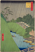
Shohei-bashi Bridge
Back : Find on a modern map Back : Find on a detailed map of Edo Back : Chiyoda-ku Back : Surugadai Ogawa-cho ezu
- Current Address
- Chiyoda-ku, Kanda Aawaji-cho / Sotokanda
- Description
- A bridge over the Kanda-gawa River which connected Kanda Awajicho and Sotokanda during the Shoho Era (1644-48). In the past it was known as Atarashi-bashi Bridge, Aioi-bashi Bridge and Imoarai-bashi Bridge. It was renamed Shohei-bashi Bridge in 1691, when the Yushima Seido Shrine and Shoheizaka gakumonjo (an official academy of the Tokugawa shogunate) were constructed on the orders of the 5th Shogun Tokugawa Tsunayoshi. The hill that climbs along the bank of the Kanda-gawa River from Shohei-bashi Bridge is Shohei-zaka Hill, and because the road was in poor condition, such that if one tripped, they would be covered in mud, and because it was a very steep slope, such that if one tripped they would roll downwards like a dango dumpling, it was also called Dango-zaka Hill.


